
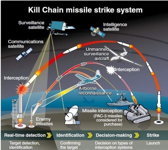
We present a comprehensive analysis of how the NEONSAT microsatellite constellation, launched aboard the Nuri rocket, overcomes the limitations of existing ground-based radars and strengthens South Korea’s defense network against North Korea’s hypersonic missiles and low-altitude maneuverable (pull-up) missiles such as the KN-23 and KN-24.
1. Limitations of Existing Ground-Based Radars and Weaknesses in the Korean Peninsula Defense Network
Due to advancements in North Korea’s missile technology, ground-based detection systems face structural limitations.
- Blind Spots Caused by the Earth’s Curvature (Horizontal Blind Spot): Ground-based radars (such as ballistic missile early warning radars and Aegis SPY-1D radars) struggle to detect low-altitude targets beyond the horizon due to the line-of-sight propagation of radio waves.
- North Korea’s ‘Maneuverable Flight’ and Low-Altitude Penetration: When North Korean missiles fly at low altitudes of 30–50 km instead of standard high-altitude ballistic trajectories and execute sudden pull-up maneuvers in their terminal phase, ground radars experience detection delays—detecting targets minutes after launch only after they breach the horizon.
- Gaps in Revisit Time: Although high-performance medium-to-large reconnaissance satellites (such as those from the Military Reconnaissance Satellite 425 Project) offer high image resolution, operating only a few units results in time gaps, requiring several hours to revisit a specific area.
2. Analysis of Complementary Capabilities Provided by Microsatellite Constellations
The five NEONSAT microsatellites placed into orbit via the Nuri rocket (with a total of 11 units planned including subsequent launches) address ground radar weaknesses through dense temporal and spatial reconnaissance capabilities.
① Pre-Launch Indication Tracking (Core Integration with the Kill Chain)
The core advantage of a microsatellite constellation is high-frequency revisit times. By imaging all regions of North Korea every tens of minutes to an hour, it captures real-time pre-launch indicators—such as mobile transporter erector launcher (TEL) movements, regional exercises, and missile positioning—enabling pre-emptive strikes by monitoring ground operations invisible to ground radar.
② Multi-Angle Look-Down Surveillance from Orbit
Positioned 575 km above the Earth looking down on the Korean Peninsula, orbital surveillance eliminates ground radar blind spots caused by curvature. Even if missiles fly at low altitudes, hiding behind terrain or foliage within the satellite’s field of view remains difficult.
③ Early Warning Synergies with Ground-Based Radars
- Phase 1 (Satellite): The microsatellite constellation is the first to detect TEL movements, plume thermal signatures, or trajectory anomalies.
- Phase 2 (Radar): Ground radars pre-orient their beam direction using satellite-provided coordinates.
- Phase 3 (Interception): Radars rapidly acquire missile trajectories as targets emerge over the horizon, reducing response time for interceptor systems (L-SAM, M-SAM, etc.).
3. Limitations and Insufficiency of Standalone Defense
However, the NEONSAT constellation alone cannot provide complete defense against low-altitude maneuverable missiles.
| Analysis Item | Limitations of Optical/EO Microsatellite Constellations |
| Nighttime & Weather Constraints | Satellites equipped with standard Electro-Optical (EO) payloads struggle to precisely identify ground targets and low-altitude aircraft during night operations or adverse weather conditions like clouds and rain. |
| Real-Time Tracking Limitations | Because small reconnaissance satellites primarily serve as still-image assets, their technical specifications limit continuous real-time trajectory tracking of low-altitude missiles traveling at speeds exceeding Mach 5. |
4. South Korea’s Future Early Warning and Defense System Expansion Plans
Starting with the NEONSAT microsatellite constellation, the South Korean government and Ministry of National Defense are building a multi-layered space security network to ensure early detection and interception of North Korean low-altitude maneuverable missiles.
[Space Sensor Layer] Microsatellite SAR + Infrared (IR) Early Warning Constellation │ (Early Launch Signs & Thermal Signature Detection) ▼[Ground/Sea Radars] Dual-Band (X/C-Band) Ground Ballistic Missile Radar & Aegis SAR │ (Precision Tracking of Variable Trajectories) ▼[Multi-Layered Intercept] L-SAM II (High-Altitude/Glider Intercept) + M-SAM Block III / Iron Dome
- Acquisition of Additional Synthetic Aperture Radar (SAR) Microsatellite Constellations: To overcome the nighttime and weather limitations of optical (EO) satellites, multiple all-weather SAR microsatellites will be deployed to establish a 24/7 surveillance network.
- Introduction of Space-Based Infrared (IR) Early Warning Satellites (K-PWSA Initiative): Modeled after the U.S. Proliferated Warfighter Space Architecture (PWSA), plans are underway to build an IR satellite constellation capable of detecting missile launch plumes and heat signatures instantly from space—providing an orbital trajectory tracking solution for low-altitude missiles.
- Evolution of Ground Interception Networks (L-SAM II and M-SAM Block III): To intercept low-altitude and glide-maneuver missiles, defense authorities are developing L-SAM II (High-Altitude / Glide-Phase Interceptor) and M-SAM Block III, extending engagement altitudes.
- C2C4I Command Automation & AI-Driven Target Allocation: AI systems will integrate constellation data and ground radar feeds in real time, calculating predicted impact points within seconds and automatically assigning target tracks to interceptor batteries across a unified defense network.
Summary & Conclusion
The deployment of the NEONSAT microsatellite constellation via the 5th Nuri launch significantly improves pre-launch indication detection and early coverage of ground radar blind spots regarding North Korean low-altitude missiles. While it effectively complements ground radar coverage, achieving full real-time tracking and interception of low-altitude maneuverable threats requires complete integration with upcoming microsatellite SAR systems, space-based infrared (IR) early warning constellations, and multi-layered interceptors such as L-SAM II.