
Tectonic Stress Accumulation along the Pacific Ring of Fire and Complex Geopolitical Risk: Scientific Data-Based Analysis and Asset Defense Strategies
Along with recent large-scale earthquakes occurring across the Pacific Ring of Fire—connecting Japan, China, Mexico, and Venezuela—warnings have emerged that stress along the southern segment of California’s San Andreas Fault has reached its highest level in 1,000 years.
This article provides a multi-dimensional analysis based on scientific data regarding the “Triple Complex Risk”—a convergence of the climate crisis, mega-natural disasters, and geopolitical war risks arising from global hegemony competition—and presents asset management solutions for investors.
1. Analysis of Tectonic Changes in the San Andreas Fault and the Ring of Fire
① The “Big One” Threat in the Southern San Andreas Fault and Scientific Data
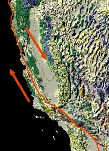
The San Andreas Fault, which spans across California, is a transform fault where the North American Plate and the Pacific Plate slide past each other.
- Limits of Stress Accumulation: The southern segment of the fault (from the Salton Sea to Wrightwood) has not experienced a major earthquake in over 300 years. As a result, strain energy generated by plate movement (approximately 20 to 37 mm per year) has not been released and remains concentrated.
- Exceeded Seismic Recurrence Interval: While the average recurrence interval for major earthquakes along the southern segment is estimated at 150 to 200 years, the segment has remained quiescent for over 160 years since the 1857 Fort Tejon earthquake (M7.9). According to research teams, including those at the University of Bern, stress levels have reached a 1,000-year peak.
- Estimated Damage Scale: Should a Magnitude 7.8 “Big One” occur, two minutes of intense ground shaking would paralyze infrastructure in Los Angeles and neighboring metropolitan areas. Direct and indirect economic losses are estimated to reach up to $1 trillion.

② Chain Variations in the Ring of Fire and High-Risk Future Areas
Subtle changes in the movement speed of the Pacific Plate and friction along subduction zones are forming high-risk seismic zones across the Pacific Rim.
[Core High-Risk Faults/Subduction Zones in the Pacific Ring of Fire]
- Cascadia Subduction Zone: Pacific Northwest, US (M9.0+ Megathrust Risk)
- San Andreas Fault: Southern California (Maximized Stress for M7.8 ‘Big One’)
- Nankai Trough: Offshore Southern Japan (M8.0–9.0 Cascading Earthquake Risk)
- Middle America Trench: Coastal Mexico to Central America (Constant M7.5+ Risk)
- Cascadia Subduction Zone (Pacific Northwest, US / Canada): A region where the Juan de Fuca Plate subducts under the North American Plate. Having reached its average recurrence interval (300 years), it holds the highest probability for a mega-thrust earthquake of Magnitude 9.0 or greater and subsequent tsunamis.
- Nankai Trough (Japan): A zone where the Philippine Sea Plate subducts beneath the Eurasian Plate. Because its epicenter lies close to major metropolitan and key manufacturing centers, a Magnitude 8 to 9 earthquake would deal a critical blow to global IT and semiconductor supply chains.
- Middle America & Andes Subduction Zones (Coasts of Chile, Mexico, and Venezuela): Active subduction of the Nazca Plate triggers frequent short-cycle earthquakes of Magnitude 7.0 or higher, threatening raw material (copper, lithium, etc.) mining infrastructure and export ports.
2. Structural Topographic Map of the Ring of Fire and San Andreas Fault
Topographic representation showing the location of the San Andreas Fault zone along the California coastline and the Pacific plate boundaries:
                  [ Pacific Plate ]
                          │ (Northwestward Movement: ~37mm/yr)
                          ▼
======================== San Andreas Fault
                          ▲
                          │ (Relative Southeastward Movement)
             [ North American Plate ]

* Primary Threat Segment: Salton Sea ──➔ Wrightwood ──➔ Los Angeles (Peak Stress)
📸 [Unsplash] Search: California fault and earthquake risk topographic map
📸 [Unsplash] Search: Pacific Ring of Fire and earthquake-related images
3. Investor Asset Defense Strategies in an Era of Complex Risk (Seismic, Climate, Geopolitical)
During periods when natural disasters and geopolitical conflicts intersect, the physical and geographical safety of assets becomes the top priority for evaluation.
① Geographical Risk Screening for Data Centers and Advanced Industrial Real Estate
Tech company data centers and precision manufacturing facilities located near Silicon Valley and Los Angeles face high fault-line exposure risks.
- Response Strategy: Asset values will appreciate for companies that diversify their supply chains and infrastructure into inland US regions away from fault zones (e.g., Texas, Arizona) or to other continents.
② Beneficiary Stocks in Disaster Recovery Infrastructure and Network Modernization
Major earthquakes cause long-term paralysis of water, power, and telecommunications networks. Capital will concentrate into companies possessing technologies in disaster prevention, smart grids, satellite communications (e.g., Starlink), and emergency power generation (ESS/hydrogen).
③ Risk Management in Property & Casualty Insurance and Reinsurance Sectors
Large-scale disasters lead to rapid short-term losses for property and casualty insurers. Investors should avoid regional insurers with high exposure to California and instead diversify into top-tier global reinsurers or alternative assets such as Catastrophe Bonds (Cat Bonds).
④ Maintaining Allocation to Physical Safe-Haven Assets (Gold & US Treasuries)
- In a complex risk environment where geopolitical conflict and mega-natural disasters occur simultaneously, it is advisable to hold more than 15% to 20% of the total portfolio in Gold, short-term US Treasury bills, and cash equivalents to secure ultimate liquidity.